Well here's a small view of the first map I drew up for DuskHaven. Raise your hands if you see the problem with it.
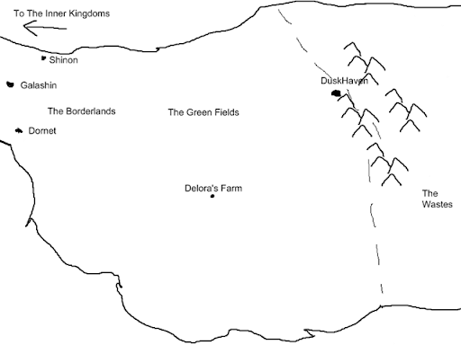
That's right, the map is backwards. DuskHaven is in the West not the East. Whoops. That's what happens when you don't pay attention to what you're doing. I'll be working on a new map of the Borderlands as well as the larger map for the continent and world in the next couple of days.
The generalities are there though. The dashed line represents the limit of demon incursions prior to the fall of DuskHaven. With the loss of the lantern all of The Green Fields have fallen under demon control and the demons are at the gates of The Borderland kingdoms now. The demons do not move as an organized army except when led by Lord Danrael. This has allowed villages months and even years in some cases to evacuate to the East. Several larger villages close to the Border Kingdoms are still standing though they are all very weakened. The area around Delora's farm stood against the demons for twenty years after the fall of DuskHaven and the farm itself has gone curiously unnoticed for the remaining ten.
As the largest growing area in Arquel the loss of the Green Fields is having repercussions even as far away as the Inner Kingdoms. Home to corn, wheat, cotton, and tobacco these fields produced much of the best food in the kingdom. They were also home to enormous cattle and livestock farms. The border kingdoms have felt the loss most heavily as they deal with the influx of refugees while trying to hold back the demon forces.